|
|
Post by kingsleybray on Apr 16, 2014 6:17:51 GMT -5
Ephriam wrote: "There are two main differences between his original 1855 diary entry and his 1856 publication. First, he rounds several of the numbers, changing the number of Sihasapa lodges from 164 to 165 for example. And second, in his published report, he omits the Eats No Dog band. I think it interesting that Warren originally distinguished the Eats No Dog band separately from the rest of the Minneconjou. Similarly, Capt. Kinney, in recording the number of lodges in the area of Fort C. F. Smith in 1867, also listed this band separate from the Minneconjou (McDermott, Red Cloud's War, vol. 1 p. 301). But in preparing his 1856 publication, he clearly reconsidered his numbers, perhaps with input from other knowledgeable individuals. Perhaps he decided that these lodges were already accounted for in the other tribes. I think he purposely left it out and that his 1856 report most closely represents Lt. Warren's understanding of Lakota population.
Lt. Warren and Capt. Simpson separate populations estimates are relative similar. While the actual numbers of lodges varies, the percentage of the total for each tribe is remarkably similar. I think this new information helps us to re-examine earlier population trends, such as what Kingsley Bray did in his excellent paper. In particular, one of the notable differences between the Warren/Simpson estimates and Bray's estimate is in the size of the Brule. If we adjust Bray's Brule count in line with Warren/Simpson, we lose most of the dramatic population decline of the 1850s that he attributed to cholera and smallpox. I think this new number shows that while epidemic diseases did impact the Brule, it was just a slow down in population growth, not a decline; and it make the population grown of the 1860s and 1870s more in line with other Lakota tribes.
Just a thought for consideration."Read more: amertribes.proboards.com/thread/2045/capt-simpsons-description-sioux-1855?page=1&scrollTo=16297#ixzz2z2xplk6CI agree Ephriam that the printed 1856 report probably represents Warren's considered rethink on his journal entry. My feeling remains that he was right first time. One place I would rewrite my population history is on Brule numbers at the end of the period covered. I think they were bigger than I reconstructed. I'll try to dig out my notes on this. |
|
|
|
Post by ephriam on Apr 19, 2014 14:32:45 GMT -5
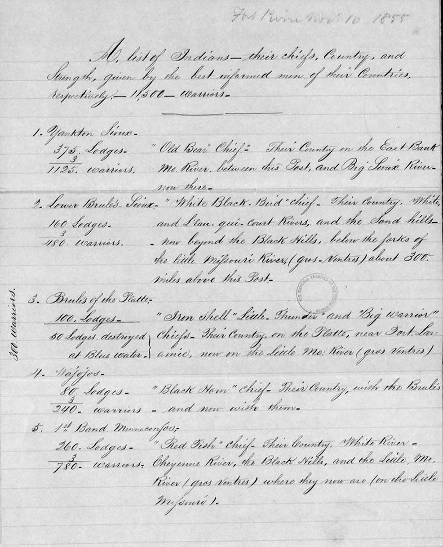
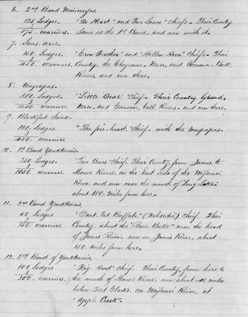
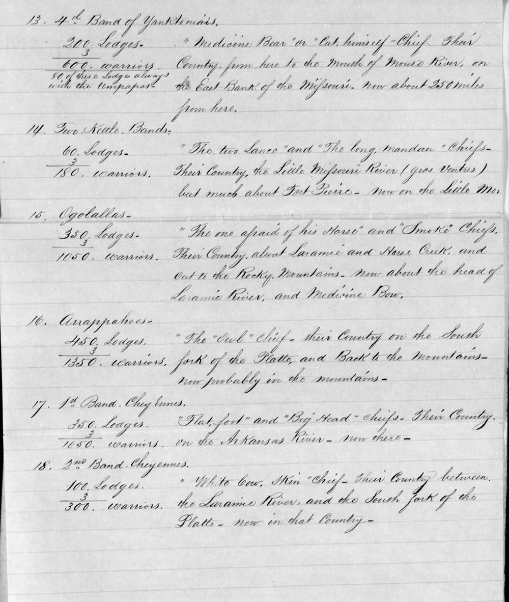
Thank you, Kingsley, for sharing Harney's 1855 list of Indian tribes. We now have three sources created by the Army as part of the Sioux Expedition of 1855 -- Capt. Simpson, Lieut. Warren and Gen. Harney. While I was at the National Archives this past week, I did some poking around to see if I could find some additional information about these sources. In the letter book of the Sioux Expedition, I found instructions to Capt. Simpson in June 1855, ordering him to proceed upriver from Fort Leavenworth to the site of Fort Pierre where the new military post was to be established. In addition to overseeing the transportation and storage of subsistence stores at Fort Pierre, Captain Simpson was also directed to gather information about the resources of the region, especially related to beef cattle, and "You are further directed to collect all the information that you can obtain in respect to the locality, condition, and disposition toward the Whites, of the various tribes and bands of Indians inhabiting or visiting the country bordering the Upper Missouri." Similarly, Lieut. Warren was also instructed to accompany the troops intended to establish Fort Pierre. His instructions were to lay out the military reservation around Fort Pierre and to conduct a general reconnaissance of the area along the Upper Missouri as far north as the mouth of the Cheyenne River. Again, he was also instructed to “collect from traders and other people of the country all the reliable information that can be obtained as to the locality, disposition and probable movements of the various bands of Indians inhabiting or visiting that region.” These two letters of instruction show that Gen. Harney was trying to gather as much information as possible about locations and strengths of the various bands. As mentioned above, I found a letter from Gen. Harney dated Fort Kearny Aug. 23, 1855 in which he mentions receiving the reports from Capt. Simpson and Lieut. Warren, which he describes as “relative to the country passed over by them, and to the Sioux Indians in general” and promises to forward copies when he could have them made. In the following weeks, of course, he had the fight on Blue Water and council meetings at Fort Laramie. Not until after he arrived at Fort Pierre himself did he take time to write up a report of his activities. Kingsley shared a summary of the list of Indians found in the Sioux Expedition Letter book. I found a second copy of this document in the letters received by the Adjutant General's Office. It is marked as enclosure B, attached to Gen. Harney's lengthy report dated Fort Pierre, Nov. 10. His only reference to the attachment is at the end of his report as he recommends a military strategy for Army posts along the California-Oregon trail and the Santa Fe trail. “The object of these Posts & those proposed on the Sante-fe route will be perceived by observing the accompanying statement (marked B) of the different Bands of Indians &c, & their countries.” There is no indication as to who the author was. It could have been Harney himself or another member of his staff. But it was certainly sent with his report on Nov. 10, 1855. His letter book suggests that he made two copies, one for General Scott at Army Headquarters and the other for the Secretary of War through the Adjutant General's Office. The Army Headquarters copy does not appear to have survived in the correspondence files, but we do now have the one from the AGO. A month later, Gen. Harney finally had time to copy and forward the two reports by Capt. Simpson and Lieut. Warren. What is interesting is that in his cover letter, he describes the enclosures as reports about “the resources of the country on the Upper Missouri, in the vicinity of Fort Pierre; one, made by Captain Simpson, Subsistence Department, the other, by Lieutenant Warren, Topographical Engineers.” He made no mention of their reports on Indian population, suggesting that this was not included. Unfortunately, Warren's enclosure is missing from the file while Simpson's enclosure is only about the resources of the Upper Missouri, not the separate document quoted above showing Indian population. Gen. Harney believed that these officers' reports about the region's resources was inaccurate. "These reports differ very materially from the reports of later dates, of other officers. The information obtained by Captain Simpson, and Lieutenant Warren, was hastily gathered from the employees of Messrs. Chouteau and others, who have been living in this Country for several years. Such persons here have no veracity, when it is to their interest to deceive." I suspect that Gen. Harney did not consider Simpson and Warren's Indian reports to be accurate either, and therefore did not forward them as part of his Dec. 14 letter. After all, from his perspective, he had already forwarded what he considered to be a more up-to-date understanding and more accurate representation of Indian population in the region. I ran out of time but will continue to see if I can find the full reports. We now have two of Simpson's reports and I found a mention in a register of a third one which I have not located yet. Also, there was clearly an official Warren report, separate from his diary entry and 1856 publication. Maybe a copy is preserved in his personal papers at the New York Public Library. While Gen. Harney may have considered his numbers to be more accurate, it is interesting to note that Warren used his own numbers in his later published reports. Either he was never provided with a copy of Gen. Harney's report or he considered his to be more accurate. Will keep working on better understanding the background behind these documents. Here is a comparison of the three different sources now: Table. Comparison of Lodge Estimates: | Tribe | Simpson, 1855 | Warren, 1856 | Harney, 1855 | Average | | Hunkpapa | 300 lodges (17%) | 365 lodges (20%) | 380 lodges (20%) | 348 lodges (19%) | | Sihasapa | 100 lodges (6%) | 165 lodges (9%) | 160 lodges (9%) | 141 lodges (8%) | | Two Kettle | 80 lodges (5%) | 100 lodges (5%) | 60 lodges (3%) | 80 lodges (4%) | | Minniconjou | 250 lodges (14%) | 200 lodges (11%) | 385 lodges (21%) | 278 lodges (15%) | | Sans Arc | 200 lodges (11%) | 170 lodges (9%) | 150 lodges (8%) | 173 lodges (9%) | | Oglala | 300 lodges (17%) | 360 lodges (20%) | 350 lodges (19%) | 337 lodges (18%) | | Brule | 520 lodges (30%) | 480 lodges (26%) | 390 lodges (21%) | 463 lodges (25%) | | TOTAL | 1,750 lodges | 1,840 lodges | 1,875 lodges | 1,822 lodges |
|
|
|
|
Post by ephriam on Apr 19, 2014 17:36:10 GMT -5
Harney's report, from Office of Adjutant General, Letters Received: Page 1:  Page 2:  Page 3:  |
|
|
|
Post by gregor on Apr 21, 2014 15:38:10 GMT -5
|
|
|
|
Post by emilylevine on Apr 23, 2014 15:27:54 GMT -5
Hi all
I don't really have anything to add to this discussion but I just wanted to say what a great thread this has been, from Ephriam's first post until Gregor's recent contribution. It is the sort of information and exchange that one can only find on this forum I think. Great stuff. Thanks to everyone.
em
|
|
|
|
Post by Dietmar on Apr 27, 2014 5:30:52 GMT -5
Ephriam´s pages are uploaded now!
|
|
|
|
Post by grahamew on May 1, 2014 17:33:10 GMT -5
|
|
|
|
Post by ephriam on Jun 29, 2014 11:49:28 GMT -5
In 1854, the year before the above information was written, Captain Oscar F. Winship made a tour of inspection of Army posts within the Department of the West, including Fort Laramie. At the end of his report, he added some additional information about Indian affairs in the area, including an estimate of the number of Lakota. He later added an addendum with information from additional sources, including Paul Carrey. (Note: Capt. Warren included a summary of the Sioux in his June 1855 journal, also provided by Mr. Carrey, which is nearly verbatim to that included in Winship's addendum.) By Capt. Oscar F. Winship: Indian Affairs, and the indications they present as to the proper military occupation of the Indian Country between the Missouri and the Arkansas.
[Fort Leavenworth, K.T., September 27, 1854] With regard to the numerous tribes and remnants of tribes which occupy the country adjacent to our frontier settlements, the Government is amply informed… With the great nomadic tribes of the plains, however it is very different…. SiouxThis great tribe of Indians is divided into a vast number of bands, covering a greater extent of country than any other, perhaps, except the Comanches. I shall confine myself to those bands habitually residing south of the Missouri, as it is with them that the government must, for the present, come in more immediate contact. The Ogalalas occupy the North Platte, and number about 300 lodges. The proportion of warriors to the lodge is strongly insisted upon, by the Sioux traders about Fort Laramie to be stronger than that fixed for the southern tribes. I will therefore allow them what they ask, three warriors to the lodge, for the Sioux bands, merrily giving it as my opinion that this is an over estimate. The Ogalalas, then, must be set down as mustering 900 warriors. They are deeply implicated in the late massacre near Fort Laramie, although they disavow any general participation in the act. One of the best evidences, however, of their guilt is, that on my way from Fort Laramie east, I passed in the vicinity of an Oglala camp, numbering some 30 lodges, near the crossing of the South Platte, and although my party did not number ten men, and presented anything but a hostile appearance, not an Indian visited us even to ask for sugar and coffee, a circumstance which was then not less agreeable than surprising to us. Big Head is the Chief of the Ogalalas, and is a very influential man.
The Brules inhabit the Country bordering the White Earth river. They number 350 lodges, and 1050 warriors. Their Chief, if he be yet living, is the Bear, the man who figured so conspicuously in the Laramie Massacre. He is a man of great influence among the Sioux, but of doubtful disposition toward the whites. I have heard that the American Fur Company have been obliged to purchase his friendship at no inconsiderable cost, and I cannot but entertain a suspicion that his professed friendship for Lieut. Grattan, cost that young officer his life, and those of his party. Certain it is that after having suggested the sending of a detachment of troops to capture a depredator residing in his own camp, he failed through inability, or want of disposition, to deliver him up, and thus brought about a catastrophe more appalling than any one of the numerous and bloody affairs which have transpired in the Indian Country within the last twelve month.
The Mincoujous occupy the country between the two forks of the Shayen [Cheyenne], and number 400 lodges, and 1200 warriors. Red Fish is their Chief. They were hostile to the government before the difficulty at Sarpy’s point, and they can scarcely have become more peaceably disposed since that event.
The Black Feet live on the Missouri, near the mouth of the Moro [sic.], not far above Fort Pierre. They number 250 lodges, and 750 warriors. Flat Foot is their Chief. The Agents, and employees of the American Fur Company can give much more valuable information concerning this, and indeed every other Sioux band than I can. It is sufficient here to say that the Black Feet are very hostile to the people of the United States.
The Oncpapas occupy the same country as the Black Feet, and are not more favorable towards the whites. They muster 350 lodges and 1050 warriors. Little Bear is their chief.
The Sans Arc live on the head waters of the Moro, number 180 lodges, and Crow Feather is their chief. I have been able to gather little other information concerning them.
Supplement to the Report on Indian Affairs
[Jefferson Barracks, Mo., October 28, 1854]
Since writing and transmitting my remarks on Indian Affairs I have gathered other information which may be of some importance in the event of operations against the Sioux Indians.
The Sioux are, as has already been said, divided into numerous bands living, some on the right, and others on the left bank of the Missouri and frequently at a considerable distance from that river. Those living on the left are called Ssentis [Santee], or Sioux of of St. Peter’s river. They are: the Warpetons or the men of the leaf, the Medoacatons, or the men of the lakes, the Cut-heads and Yanktonnais, who winter near the Mandans, opposite the mouth of Heart River, and on Beaver Creek. Some Ssentis are always on the Big Sioux River, and above.
The Bands of the right banks are: the Yanktons, who are sometimes on the left bank. They winter ordinarily near White Earth River. The Brules winter on the North Platte, Eau Qui Court [Niobrara] and White Earth rivers. The Miniconjoux, the Sans Arcs, Oncpapas and Blackfeet, winter on the Big Cheyenne (Shyen on the maps), the Moreau and the head of the Heart rivers. The Oglalas winter on both forks of the Platte, frequently with the Cheyennes.
I am indebted for the above information chiefly to Mr. Paul Carrey, a very intelligent French voyageur and to Mr. Picot, late of the American Fur Company, who is perfectly acquainted with nearly all the Upper Missouri country… Also to Mr. Jouett, an old inhabitant of the Sioux country, for information relative to the various tribes and bands of that great Indian nation.
So... here is a comparison of Winship's numbers with those provided by Simpson, Warren and Harney (who possibly got them from Winship who by 1855 was serving as Harney's adjutant general on the Sioux Expedition.):
Table. Comparison of Lodge Estimates:
| Tribe | Winship, 1854 | Simpson, 1855 | Warren, 1856 | Harney, 1855 | | Hunkpapa | 350 lodges (19%) | 300 lodges (17%) | 365 lodges (20%) | 380 lodges (20%) | | Sihasapa | 250 lodges (14%) | 100 lodges (6%) | 165 lodges (9%) | 160 lodges (9%) | | Two Kettle | not mentioned* | 80 lodges (5%) | 100 lodges (5%) | 60 lodges (3%) | | Minniconjou | 400 lodges (22%) | 250 lodges (14%) | 200 lodges (11%) | 385 lodges (21%) | | Sans Arc | 180 lodges (10%) | 200 lodges (11%) | 170 lodges (9%) | 150 lodges (8%) | | Oglala | 300 lodges (16%) | 300 lodges (17%) | 360 lodges (20%) | 350 lodges (19%) | | Brule | 350 lodges (19%) | 520 lodges (30%) | 480 lodges (26%) | 390 lodges (21%) | | TOTAL | 1,830 lodges | 1,750 lodges | 1,840 lodges | 1,875 lodges |
*probably included in Winship's calculations for the Sihasapa.
|
|
|
|
Post by montana1768 on Jun 30, 2014 22:14:02 GMT -5
|
|


